|
CCPP SciDoc
v6.0.0
Common Community Physics Package Developed at DTC
|


|
|
CCPP SciDoc
v6.0.0
Common Community Physics Package Developed at DTC
|
|
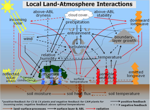
Land-atmosphere interactions are a main driver of Earth's surface water and energy budgets. The importance of the land surface is rather intuitive, and has been demonstrated not only in terms of predictability on daily to seasonal timescale (Betts et al. (2017) [27]), but also in terms of influencing extremes such as drought and heatwaves (Paimazumder and Done (2016) [151]), PBL evolution and cloud formation (Milovac et al. (2016) [134]) and afternoon convection (Guillod et al. (2015) [75]), and tropical cyclone re-intensification (Andersen and Shepherd (2014) [5]). Other linkages, such as the role of soil moisture (SM) or vegetation heterogeneity in mesoscale circulation (Hsu et al. (2017) [94]) and planetary waves (Koster et al. (2014) [108]), and those driven by land use and land cover change or management (Hirsch et al. (2015) [87]; Findell et al. (2017) [59]) are topics of active research.
Figure 1 is a schematic of local land-atmosphere interactions in a quiescent synoptic regime, including the soil moisture-precipitation (SM-P) feedback pathways (Ek and Mahrt (1994) [51]; Ek and Holtslag (2004) [50] ). Solid arrows indicate a positive feedback pathway, and large dashed arrows represent a negative feedback, while red indicates radiative, black indicates surface layer and PBL, and brown indicates land surface processes. Thin red and grey dashed lines with arrows also represent positive feedbacks. The single horizontal gay-dotted line (no arrows) indicates the top of the PBL, and the seven small vertical dashed lines (no arrows) represent precipitation
Recently, the land surface updates in 2017 GFS operational physics includes: